The geology and landforms of the Kawarthas tell an amazing story.
Peterborough Examiner – November 10, 2023 – by Drew Monkman
If there’s a metaphor that best describes the location of Peterborough County, it’s “sitting on the edge.” On a map, the edge is simply an irregular line running across the middle of the county, dividing the Canadian Shield to the north from the Great Lakes – St. Lawrence Lowlands to the south. To a nature enthusiast, however, the edge – also known as The Land Between – represents the meeting point of two worlds: pink granite, white pine, and loons to the north and farmland, white cedar and cardinals to the south. The co-existence of these two physical regions in the Kawarthas results in a wonderful diversity of habitats and species.
The North
Let’s begin with an exploration of the northern half of the county, starting roughly at Buckhorn or Burleigh Falls. The Precambrian rocks of the Canadian Shield are unfathomably old – 600 million to over 3 billion years of age – and they underlie much of the North American continent. They also have diverse origins. Many, such as the abundant pink granite we love so much, are igneous rocks pushed up from the Earth’s interior. When the molten rock cooled, it hardened into a mass of crystals. Other areas of the Shield were originally covered with sedimentary rocks that formed from sediments that were deposited onto the beds of ancient seas.
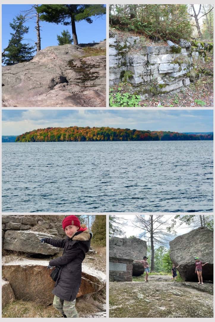
Some of the original igneous and sedimentary rocks were in turn subjected to intense pressure and heat when movements of the Earth’s crust carried them deep underground. They were transformed into metamorphic rock . Some can be seen at Petroglyphs Provincial Park where ancient limestone was changed into a massive white marble deposit. In other areas, sandstone was transformed into quartzite and granite into gneiss.
Many of the rock types to be found on the Shield can be seen in road cuts. A particularly good example is at Haultain, just north of Woodview on Highway 28. However, the rocks you are looking at in these cuts represent only a tiny fraction of what was here originally. It’s believed that the Shield was once covered by huge mountains, higher than the Rockies of today. Over hundreds of millions of years, however, the mountains were worn down by erosion to little more than rolling hills.
The South
As the Precambrian mountains weathered away, much of the eroded material ended up in a giant inland sea of warm, shallow water. The sea covered a large part of the area we now know as the Gulf of St. Lawrence and the Great Lakes Basin. Over 20 million years, huge amounts of sediments, including the shells of minute sea creatures, formed deposits on the sea floor. The shells of these creatures were composed of calcium carbonate in the form of the mineral calcite.
Eventually, as a result of cementation and the incredible pressure of their own weight, the deposits hardened into layers of 450-year-old Ordovician limestone and shale. Because the sea supported a plentiful and diverse bottom-dwelling fauna, much of the limestone is rich in fossils like trilobites, brachiopods and even corals. You can clearly see some of these fossils at the entrance to the Orange Trail at Camp Kawartha. See https://tinyurl.com/4wcus9ws
The contact zone between the ancient Precambrian rock to the north and the younger Ordovician limestone to the south is clearly visible at the junction of Douro 2nd Line and County Road 6, northeast of Lakefield. Here, you’ll find about a metre of limestone lying directly on top of the ancient Shield rock below. You can imagine yourself standing at this very location millions of years ago as the warm waters of the inland sea lapped up against the already-ancient Shield rocks.
If you return to Highway 28 and drive north through Burleigh Falls to Woodview, you can see rock cuts of what is called an “outlier.” This is an island of limestone located some distance north of the St. Lawrence Lowlands and completely surrounded by Shield rock. By the same token, there are occurrences of old Shield rock that project up through areas that are otherwise completely limestone. Lynch’s Rock is a particularly fine example of one of these “inliers.” It’s located right at the junction of Douro 5th Line and Lynch’s Rock Road and consists of a rounded, small hill of granite and gneiss surrounded by limestone. The road passes directly over this hill.
Glacial landforms
Starting about 1.65 million years ago, ice sheets (glaciers) began to form over subarctic Canada and to advance southward across much of the continent. Each advance was followed by a melting phase during which time the ice sheet shrank back to its point of origin. This occurred at least four times. The last glacier to cover the Kawarthas peaked at about 21,000 years ago and only completely melted about 9,000 years later. Measuring as much as 2.5 km thick, the ice would have extended higher than the puffy cumulous clouds that often dot the sky on a sunny day. The ice sheet was not only thick and heavy, however, but it was continually on the move.
As the glacier advanced, the ice scraped the ground underneath, almost like an unimaginably thick piece of sandpaper. In the process, soil, gravel, rocks and boulders were incorporated into the ice. Some of the boulders – known as “erratics” – were moved huge distances. Several gigantic erratics like the Adam and Eve Rocks can be seen right in the village of Buckhorn.
The ice sheets removed and redeposited mammoth amounts of rock and soil. In the process, the landscape was completely transformed. Each successive advance of the ice, however, completely wiped out the changes left by its predecessor. This means that we only have clear evidence for the advance of the last ice sheet known as the Wisconsin. Much of the transformation to the land actually occurred when the ice sheets were melting back. The huge amounts of meltwater deposited material into the landforms we see south of the Shield today: drumlins, moraines, eskers, glacial spillways and more.
Drumlins are the most visible of these. Covering over 900 square kilometres, the Peterborough Drumlin Field is one of the largest occurrences of drumlins in North America. Most of these oblong hills are located east of Peterborough but some, like Armour Hill, are in the heart of the city. Averaging several hundred metres wide and up to a kilometre in length, they are all oriented in the southwestern direction the glacier was moving. Their profile often resembles an upside down spoon with the handle of the spoon at the southern end.
For an in-depth description of the physical landscape of our area and a selection of drives you can take to see many of these landscape features, I recommend reading “Peterborough and the Kawarthas (Third Edition)” edited by Peter Adams and Colin Taylor. It is available at the Peterborough Public Library.
To read an excellent guidebook to local geology, including suggested drives, go to https://tinyurl.com/34sfbwdw
CLIMATE CHAOS UPDATE
Alarm: Canada could lead the world in oil production growth in 2024. Canada’s oil production is set to jump by about 10 per cent over the next year and become one of the largest sources of increased supply around the world. This would mark an all-time high for Canadian production. Alberta’s oilsands is expected to drive much of the growth. See https://rb.gy/rccyte
Events: On Monday, November 13 from 7:00 to 8:00 pm, For Our Grandchildren will be holding a special edition of 4RG Meets. The theme is “Climate Change: Share Your Successes”. Our future is not limited by what we currently think is possible. What we do NOW helps to shape the future, and sharing our successes with like-minded people can inspire the activist in all of us. Register for this Zoom event at https://rb.gy/6zg1br
Carbon dioxide: The atmospheric CO2 reading for the week ending November 4, 2023 was 419.05 parts per million (ppm), compared to 416.41 ppm a year ago. Carbon dioxide acts like a blanket, trapping some of the heat that Earth would have otherwise radiated out into space. As CO2 rises, the blanket gets thicker and Earth heats up more.