Part 2 of a 3 part series
This week, I would like to continue my exploration of some of the best nature-viewing areas in the Kawarthas by looking at destinations located mostly north of Peterborough. I have started in the northeast with the Carden Alvar near Kirkfield and worked eastward towards the Havelock area.
To see a detailed list of what bird species can be found in the more popular destinations (e.g., Lakefield Sewage Lagoons, Petroglyphs Provincial Park, Carden Alvar) go to ebird.org. Click on Explore Data, Explore a Region, type in Peterborough or Kawartha Lakes, click on Hotspots, click on the destination of your choice and then click on Bar Charts. You will see a list of all birds seen, along with their seasonal abundance.
Nature destinations in the Kawarthas (note: Not all destinations in this article appear on the map) Dylan Radcliffe
Carden Alvar: Located northwest of Lindsay, about 75 minutes from Peterborough via Hwy 7 and Kawartha Lakes Co. Rd. 6. From Kirkfield, take Co. Rd. 6 north and turn right onto McNamee Rd. Explore concessions such as Wylie Rd., Shrike Rd. and Alvar Rd. Highlights: Best early summer birding destination in southern Ontario, especially for uncommon and rare grassland birds (e.g., Loggerhead Shrike, Upland Sandpiper, Eastern Bluebird) and marsh birds (e.g., Sedge Wren); unique alvar plant communities (e.g., Prairie Smoke, Indian Paintbrush) Google “Carden Alvar Birding Guide” Right now (mid-June) is the best time to go!
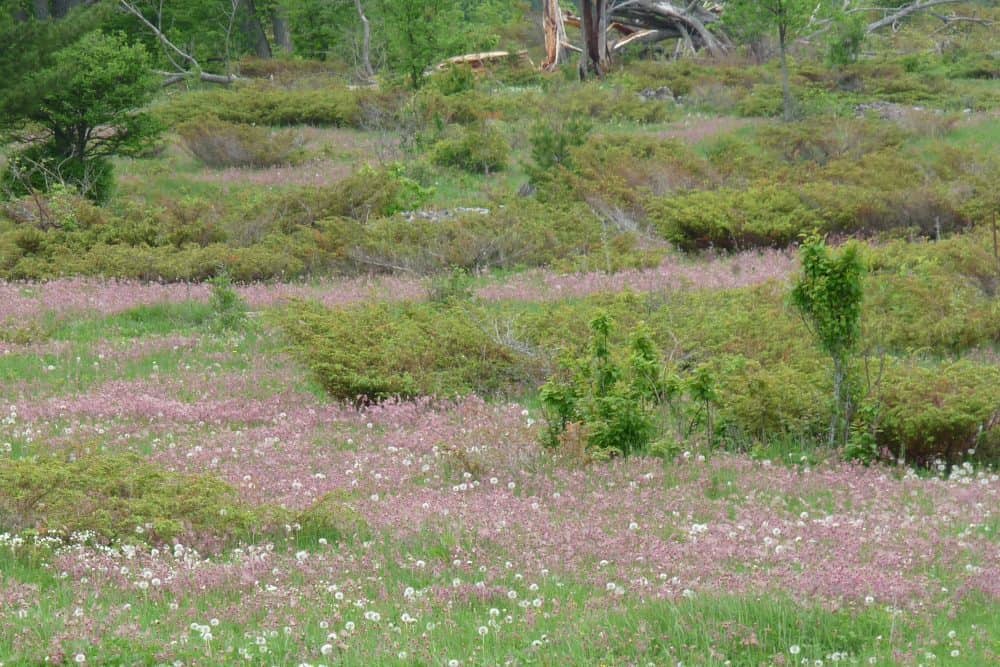
Prairie Smoke (pink) on the Carden Alvar – Drew Monkman
Altberg Wildlife Sanctuary Nature Reserve: About 70 minutes from Peterborough via Kawartha Lakes Co. Rd. 49 and 121. From Kinmount, Co. Rd. 45 west for 7 about km. The property is at address marker 4164. Highlights: 470 hectares of high-quality forest straddling the contact between the granite rocks of the Canadian Shield and the limestone of the Great Lakes – St. Lawrence Lowlands; great diversity of habitat types, breeding birds and flora. For more information, Google: “Altberg Wildlife Sanctuary”
Ken Reid Conservation Area: From the junction of highways 7 and 35, go 5 km north on Hwy 35. Turn right on Kenrei Park Rd. and go 3 km. Highlights: Forest, fields and huge marsh with boardwalks; high density of active Osprey nests
Emily Tract: Located on Peace Rd. (Kawartha Lakes Co. Rd. 14) just west of Cowan’s Bay and Emily Provincial Park: Highlights: wide variety of mature trees including old pines; excellent display of wildflowers in spring
Gannon’s Narrows: On Co. Rd. 16 north of Ennismore at junction of Pigeon and Buckhorn lakes. Highlights: Waterfowl in winter, spring and fall; eagles possible; otters on ice.
John Earle Chase Memorial Park Trails: Just north of Gannon’s Narrows. Park 0.6 km down Anchor Bay Road. Highlights: Three new trails totaling 7.5 km. Partnership between Kawartha Land Trust, Trent Severn Waterway and Municipality of Trent Lakes. Mature maple forests, rich wetlands and great views of Pigeon Lake. Go to Kawartha Land Trust site for info and map.
Big (Boyd) Island: Situated at north end of Pigeon Lake, this 1100-acre Kawartha Land Trust is only accessible by boat. You can park and launch a canoe from Bear Creek Road on the east side of the lake. Go to Kawartha Land Trust site for info and map. Highlights: extensive wetlands; large marsh and island complex; limestone cliffs on west shore and granite cliffs in the northeast (a microcosm of The Land Between); diverse bird life (e.g., Eastern Towhee, Golden-winged Warbler); alvar habitat; old growth Eastern Hemlock (west side); impressive diversity of ferns
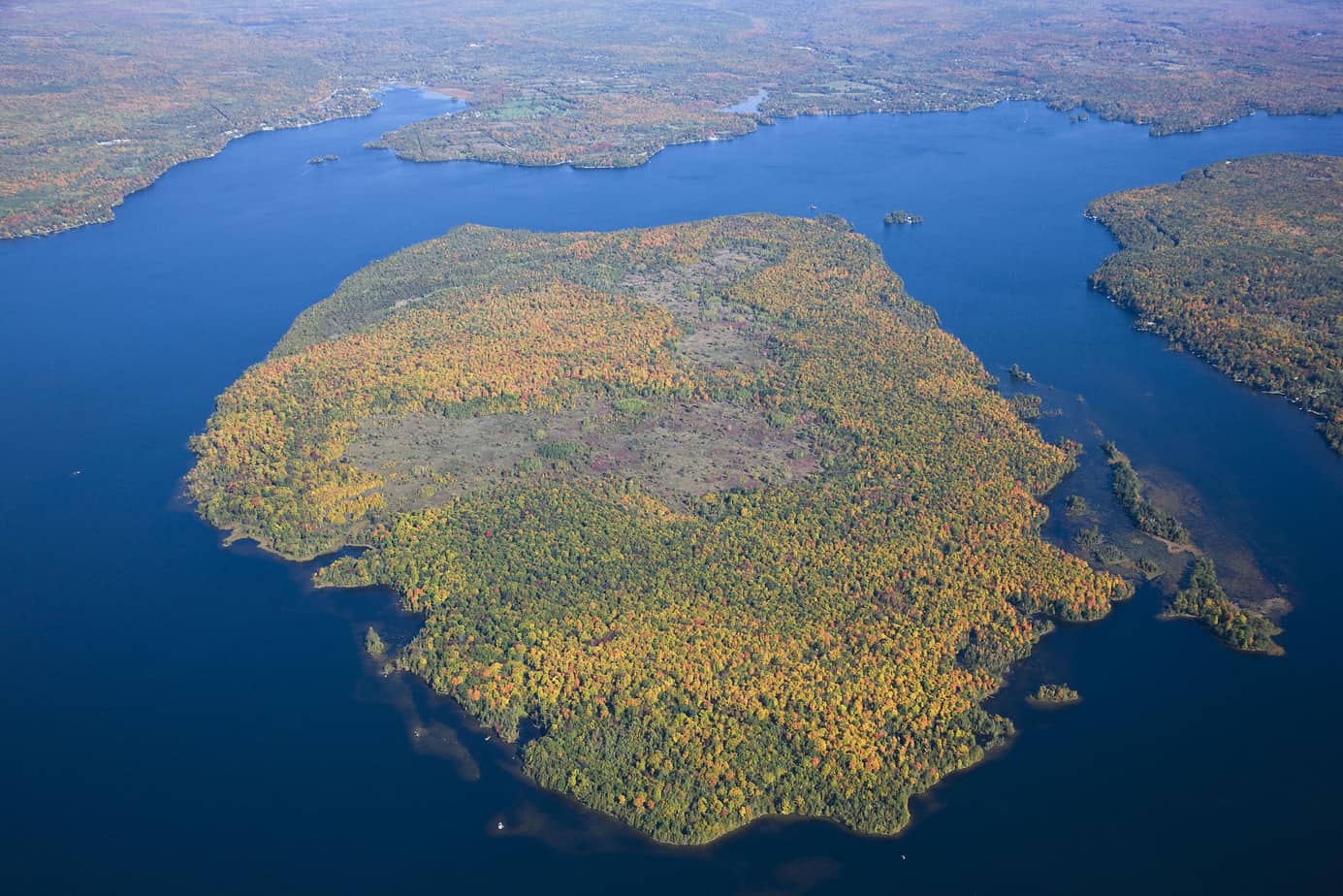
Aerial View of Boyd Island – Kawartha Land Trust
Galway-Cavendish Forest Access Road: From Buckhorn, take Co. Rd. 36 north to Co. Rd. 507 and follow north to just past the Mississauga Dam Rd. Turn west onto Galway-Cavendish Forest Access Rd.. Highlights: excellent butterfly diversity, including rarities such as West Virginia White; watch for some species perched on road (e.g., Eastern Comma, Compton’s Tortoiseshell)
Bridgenorth Trail: Located between Hilliard Street North (at 5th Line) and Brumwell St. (off East Communication Rd. on east edge of Bridgenorth) Highlights: birds, butterflies (especially gravel pit at Bridgenorth end), amphibians, late-summer flowers
Selwyn Beach Conservation Area: Located on east shore of Chemong Lake, at 2251 Birch Island Rd. Access from 12th Line of Selwyn. Highlights: A nature trail passes through wetland, woodland and open field; impressive stands of beech, maple and oak; excellent wildflower display in May
Lakefield Sewage Lagoons: On southeastern edge of Lakefield. Turn east off Co. Rd. 32 (River Rd) onto Co. Rd. 33. Parking on right. Open to public, but avoid blocking the gate. Footpath around gate on east side of parking area. Both lagoons are worth checking. Highlights: Wide variety of migrating ducks in spring and fall; rare Black Terns in summer; diverse songbirds. Number one eBird Hotspot in Peterborough County. Spotting scope useful.
Lakefield Marsh: Located at south end of Lake Katchewanooka. Turn north off Co. Rd. 29 (Bridge St.) onto Clement St. Turn right on D’Eyncourt St. Follow signs. Highlights: Wetland birds including Black Terns, American Bittern and migrant ducks; large assortment of dragonflies and damselflies in summer, especially when explored by canoe; observation tower and interpretive signage.
Lake Katchewanooka: The lake is best viewed from the bottom of Stenner Rd. off east side of Hwy 28, just north of Lakefield. Highlights: Waterfowl in fall, winter and especially spring; eagles possible all year. Often perch in pine trees on the islands to the south
Miller Creek Wildlife Area: On 7th Line of Selwyn, about 2 km west from Co. Rd. 24. Highlights: Wetland birds (e.g., American Bittern, Virginia Rail, Swamp Sparrow) in swamp at southern end of main trail. Marsh at observation tower now mostly grass-covered. Watch and listen for Sandhill Cranes.
Camp Kawartha: Located at 1010 Birchview Road, north of Lakefield. Park beside Camp office. Highlights: Explore the large network of trails on west side of Birchview Road, opposite the Camp. Wetland, woodland and alvar-like habitat. Detailed trail interpretive guides for orange and yellow trails can be found online at campkawartha.ca/orange-trail-guide and campkawartha.ca/yellow-trail-guide/ If possible, check in first at camp office.
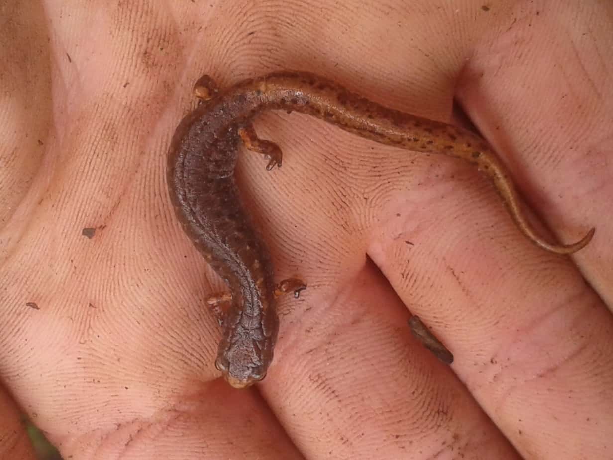
Four-toed Salamander at Camp Kawartha (Jake Fell)
Lynch’s Rock Road and Sawer Creek Wetland: Follow Hwy 28 north almost to Lakefield. Turn east on Strickland Rd. and then north on Douro 5th Line. Turn east on Lynch’s Rock Rd. and follow through Sawer Creek Wetland Wildlife Area. Continue south along Douro 3rd Line. Highlights: Large wetland with nesting Least Bittern. Sandhill Cranes and Upland Sandpipers possible in fields adjacent to Douro 3rd Line.
Warsaw Caves Conservation Area: Take Co. Rd. 4 north from village of Warsaw. Turn east at Cave Rd. Follow signs. Highlights: Fascinating limestone geologic formations including kettles and caves; large variety of ferns including Walking Fern; variety of habitat types
Kawartha Highlands Provincial Park: Located north of Buckhorn Lake between Co. Rd. 507 and Hwy 28. Access points include Coon Lake Rd., Long Lake Rd. and Anstruther Lake Rd. Best explored by canoe. Highlights: A huge Canadian Shield park with vast rock barrens and strong wilderness qualities; high-quality bogs, fen communities, alvar and Atlantic coastal plain plant communities; mature forest stands; high concentrations of Whip-poor-will and Common Nighthawk; dark skies for astronomy.
Silent Lake Provincial Park: Located on Hwy 28 between Apsley and Bancroft, about 70 minutes from Peterborough. Highlights: Diverse habitats, including mixed medium-aged forests, sphagnum bogs (abundant Pitcher Plants and Rose Pogonia at southeast end of lake), beaver meadows; valleys support 25 fern species
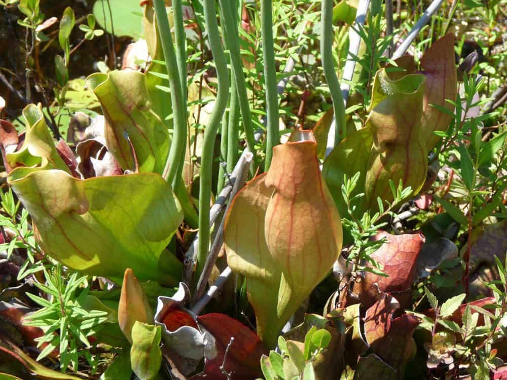
Pitcher Plants growing in a bog in Silent Lake Provincial Park (Drew Monkman)
Jack Lake Road: Turn south off Co. Rd. 504 on east side of Apsley. Follow to Jack Lake and then west and south to sand and gravel pits at end of road. Highlights: birds (e.g., crossbills in tamarack bog just south of Hwy 504); large variety of butterflies, especially in bog and in sand/gravel pits further south; abundant deer
Stony Lake Trails: Follow Hwy 28 north from Burleigh Falls to Mt. Julian Viamede Rd. Turn right and continue to Reid’s Rd. Park at address marker 105. Highlights: 10 km of well-marked, interconnected trails with benches. Open to the public thanks to a special agreement with landowners, including Kawartha Land Trust. Deciduous forest on limestone bedrock with moss and fern-rich gully called “The Chute” (Blue Trail); mixed forest on Canadian Shield granite with large groves of hemlocks, extensive wetland, vernal ponds (Yellow and Red Trails). Go to Kawartha Land Trust site for info and map.
Stony Lake Trails – Kawartha Land Trust
Petroglyphs Provincial Park: Follow Hwy 28 north from Burleigh Falls to just past Woodview. Turn right on Northey’s Bay Rd. and follow for about 11 km. Highlights: Situated on southern edge of Canadian Shield; excellent birding and botanizing (e.g. Pink Lady’s-slipper)on Nanabush Trail; large stands of Red and White Pine; abundant White-tailed Deer; birds of interest include Bald Eagle, crossbills, Evening Grosbeak, warblers and sometimes Black-backed Woodpecker; Five-lined Skinks fairly common; diverse butterflies along edges of roads and wetlands.
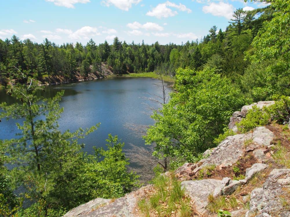
Minnow Lake on the Nanabush Trail – Drew Monkman
Hubble Road: Follow Co. Rd. 6 along south shore of Stony Lake and turn right at Co. Rd. 44. Continue southeast for about 4 km to Hubble Rd. on right. Highlights: Woodland and alvar-like habitat with uncommon birds such as Golden-winged Warbler, Whip-poor-will and Eastern Towhee.
The Gut Conservation Area on Crowe River: From Apsley, drive east on Co. Rd. 504 to Lasswade. Continue east for about 7 km. Watch for signs. Highlights: Impressive gorge in basaltic rock; Canadian Shield birds; impressive showing of spring wildflowers in May; abundant ferns and mosses
Sandy Lake Road: From Co. Rd. 46, turn right about 6 km north of Oak Lake onto Sandy Lake Rd. Highlights: Diverse butterflies including uncommon skippers (e.g., Mulberry Wing, Broad-winged in summer) along the edge of the sedge marshes; uncommon spring butterflies in May (e.g. Chryxus Arctic, Olympia Marble); Pine Warblers in pines; eagles and crossbills in winter.
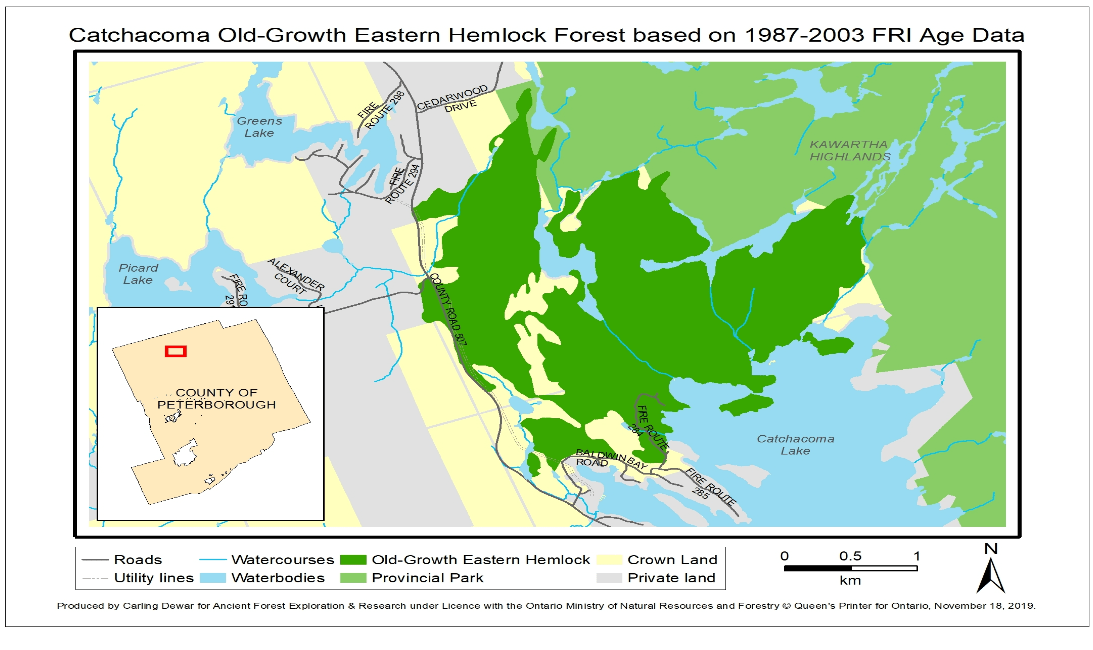
Catchacoma Hemlock Forest: The Catchacoma Forest is a 662-hectare stand of mature and old-growth eastern hemlock woods located on crown land north of Catchacoma Lake in Peterborough County. Some of the assessed trees are up to 375-years-old. There is a small network of trails. Highlights: a diverse eastern hemlock ecosystem with many huge trees as well as species such as blackburnian warbler, black-throated green warbler, fungi, etc.
Next week, I’ll look at some destinations south of Peterborough.