Some local road trips for the geographically-curious
Peterborough Examiner – December 8, 2023 – by Drew Monkman
My recent articles on the geology and landforms of the Kawarthas (Nov. 10) and on the formation of our rivers and lakes (Nov. 25) both garnered a large response. This has inspired me to propose several self-guided tours you can do to see some of the features first-hand.
Much of the content in today’s column comes from Chapter 11 of “Peterborough and the Kawarthas” (3rd edition), edited by Peter Adams and Colin Taylor. In this chapter, former Trent University geographers Alan Brunger and Fred Helleiner provide a selection of local field trips, including historical points of interest.
You will also find field trips in “Geology and Scenery: Peterborough, Bancroft and Madoc Area” by D.F. Hewitt (1969). You can read a PDF of the book at https://tinyurl.com/4hmx9pd8 The book explores local geology in great detail.
Rice Lake tour
1.Starting in Peterborough, take Highway 7 towards Port Hope. Continue just past County Road 15 and stop half way down the hill at Cathcart Crescent. Look south to view the huge flat area formerly occupied by glacial Lake Peterborough. The Oak Ridges Moraine stands out prominently on the horizon.
2. Continue south to Rice Lake Drive and follow it into Bewdley. From the village, you can see drumlin islands in the lake.
3. Return to County Road 28 and continue south. As you climb the high, wooded ridge, you are crossing a narrow section of the Oak Ridges Interlobate Moraine. The moraine was created where two advancing lobes of ice converged, depositing their contents in a broad, irregular ridge extending from Peel Region to Northumberland County.
3. Turn right on County Road 9 and drive east along the moraine towards Kirby on Highway 115. For a spectacular view, stop at Richardson’s Lookout Conservation Area about 2 km past Garden Hill. Detailed information about the moraine can be found at https://www.oakridgesmoraine.org/
Canadian Shield contact tour
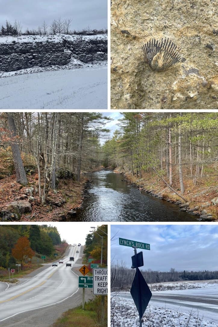
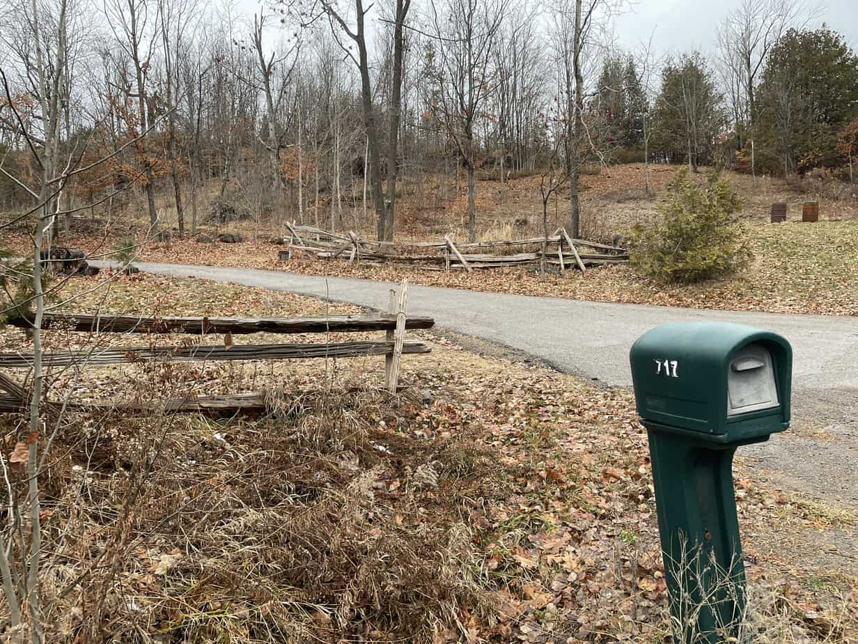
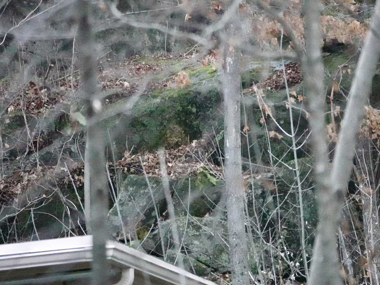
1.Starting in Lakefield, follow Strickland Street east to Highway 28. Cross the highway and continue east on Strickland Road which becomes Douro 5th Line. Turn right at Lynch’s Rock Road and continue for about 2 km to house number 717. The house is located on the side of the “rock” which is really more a rounded hill. It is a fine example of an “inlier”, a hill of crystalline rock (granite and gneiss) surrounded by sedimentary rock (limestone). From the roadside at the bottom of the rounded hill, you can see the transition in rock types. You can also see a large area of crystalline rock if you look carefully above and behind the garage of the house.
2. Take Douro 5th Line north to County Road 6. Turn right and continue to Douro 2nd Line. At the corner, you’ll see a low rock-cut called an “unconformity”. It represents a significant time gap in the geologic record between the rock present above and below. Here, younger limestone layers lie visibly on top of the much older Precambrian rocks (gneiss). The layers are in the same position they occupied when sedimentary deposits were laid down on top of the Precambrian ocean floor 450 million years ago.
3. Return to Highway 28 and drive north to the south side of Burleigh Falls. Stop at Stricker’s Lane. Here you can see a steep limestone hillside that was eroded by the ancient rivers that carved out Stoney, Lovesick, Lower Buckhorn and Bald Lakes. The hillside extends for kilometres westward forming cliffs along the south shore of Lower Buckhorn near Deer Bay.
4. Continue north a short distance to the intersection of Highway 28 and County Road 36. A rock-cut here reveals beautiful red granite and metamorphic gneiss as well as veins of quartz. Head west to Buckhorn or continue north to Stoney Lake and Petroglyphs Provincial Park.
Buckhorn area
1.Follow County Road 36 west towards Buckhorn. At several points there are obvious “outliers” (areas of younger rock surrounded by older rock) of limestone sitting on top of the buried Precambrian rocks.
2. At the south end of the bridge in Buckhorn, you’ll see a huge granite boulder known as an “erratic”. It was carried there by the ice and deposited when the glacier melted. Two more erratics can be seen on Adam and Eve Road on the western edge of Buckhorn.
3. Take County Road 36 about 3 km north from Buckhorn to Kawartha Highlands Signature Park. There is a beautiful 1.5 km trail here that follows the edge of the Mississauga River and takes you over large expanses of exposed granite. You can see cliffs of layered limestone on the opposite side of the river.
Stoney Lake area
1.From Burleigh Falls, drive north on Highway 28 to Woodview. The Woodview area has numerous limestone outliers. Watch for a high, limestone roadcut just south of Northey’s Bay Road.
2. Take Northey’s Bay Road east to Petroglyphs Provincial Park. This is a sacred site for the Algonquian First Nations of our area. The stone is generally believed to have been carved by the Algonquian or Iroquoian speaking people between 900 and 1100 AD. Today, the carvings are called Kinomagewapkong, meaning “the rocks that teach” or “the Teaching Rocks”. The 1200 carvings were made using gneiss hammers to cut human figures, boats, mythological forms, and animals into the crystalline (metamorphosed) limestone.
3. At the end of Northey’s Bay Road, turn left onto County Road 6 and follow a few kilometres to the entrance to an open-pit nepheline syenite mine operated by Covia Holdings (formerly Unimin). Nepheline is an igneous rock similar to granite. The mineral is used in the production of glass bottles, paint, ceramics, and tiles.
Single points of interest
1. Fossil hunting: The Lakefield Speed Skating Oval off of Lakefield Road adjacent to the water tower is a good destination for fossils. They are also abundant in the abandoned Lakefield limestone quarry, situated on private property just north of County Road 33 and west of Highway 28. The fossils here include corals, echinoderms, bryozoans, brachiopods, gastropods, nautiloids and trilobites. The nearby roadcut along the highway also yields fossils.
2. Omemee Esker (the “Hogsback”): Take Parkhill Road/Haye’s Line west from Peterborough and follow to where it ends at Ski Hill Road south of Omemee. Park and climb the hill onto a section of the Ganaraska Trail which follows the crest of the ridge. Known as an “esker”, the ridge extends for 20 km and is composed of gravel and other sediment deposited by meltwater from the retreating ice sheet that covered the Kawarthas 12,000 years ago.
3. Warsaw Caves Conservation Area (289 Caves Road, Warsaw): Ten thousand years ago, the Indian River was a major spillway draining glacial Lake Algonquin. The river created caves and kettles (bowl-shaped depressions) in the limestone bedrock. The caves form an interconnected network of subterranean passageways, only negotiable on hands and knees. Other features here include a scenic gorge 25 metres deep and a bare limestone plain known as an alvar.
4. Armour Hill drumlin (Hunter Street East): One of the largest drumlins in the area, Armour Hill has the typical “upside-down spoon” drumlin shape. The steep, bowl end of the spoon begins at McFarlane Street and the gently-tapering handle of the spoon ends at Sophia Street.
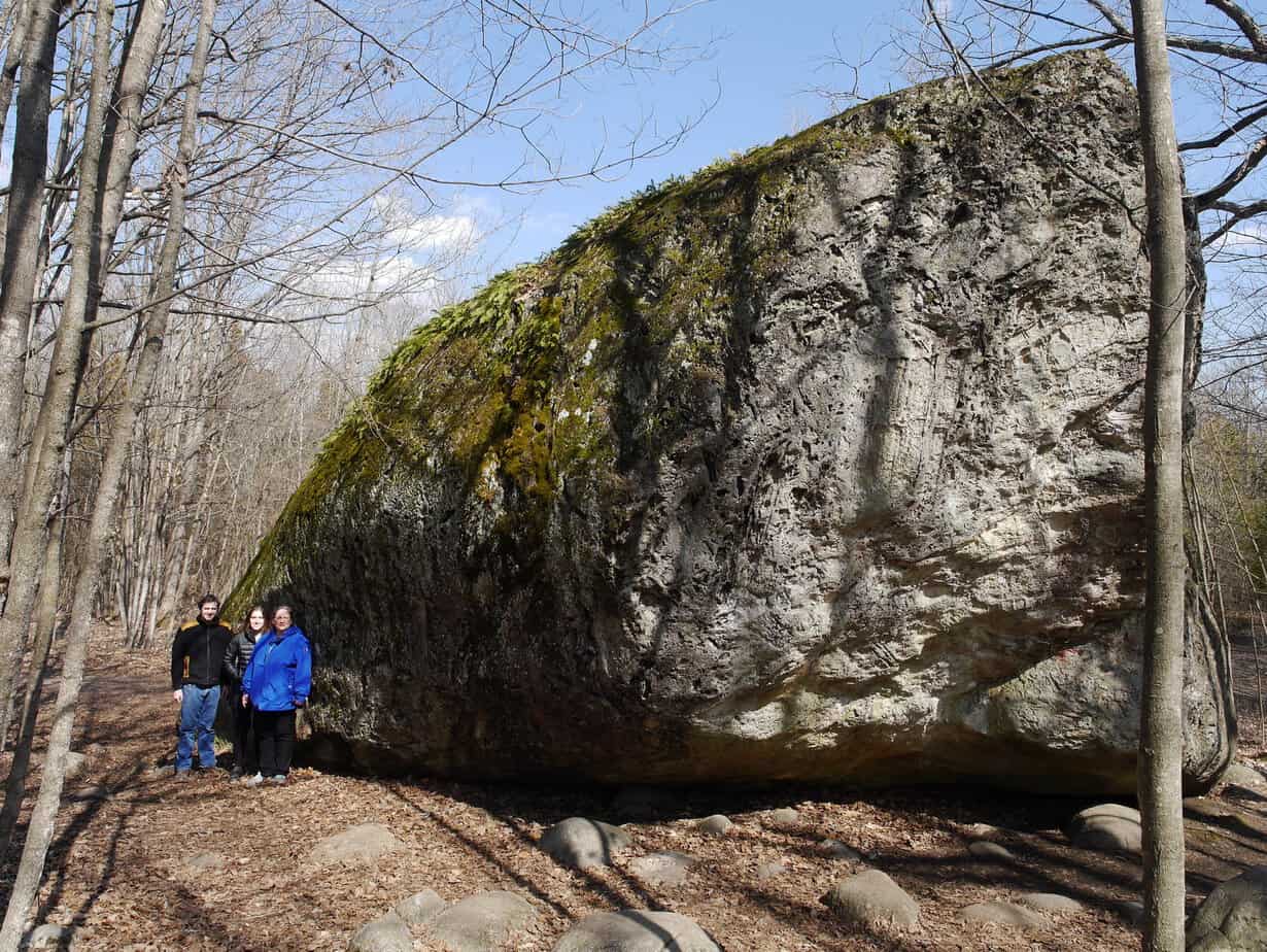
5. The Bleasdell Boulder, Ontario’s largest erratic, is located in the Bleasdell Boulder Conservation Area, just north of the 401 at Trenton on County Road 33. It is thought to have been carried by glaciers from the Madoc area. The boulder is over two stories tall (6.7 metres), 3.4 metres long, and 7.3 metres wide (44’ x 24’ x22’). It’s a sight to behold in person. You could drive down through Campbellford and maybe stop at Empire Cheese, Dooher’s Bakery, World Finest Chocolate outlet store, or the Church-Key Brewing Company.
CLIMATE CHAOS UPDATE
Solutions: Axing the carbon tax as Pierre Poilievre wants to do would also axe the rebates. So, on balance, how would Canadians fare? Statistics Canada’s Social Policy Simulation Database and Model offers some answers. According to Trevor Tombe, an economics professor at the University of Calgary, “If we got rid of the carbon tax and the rebate then this would harm a much larger fraction of lower- and middle-income households than it would higher-income households.” The model shows that 94 per cent of households with incomes below $50,000 receive rebates that exceed their carbon-tax costs in 2023. Tombe also said that if Canada is going to achieve the same emissions reduction target but with tools other than carbon pricing, they will have greater economic costs. See CBC News at https://tinyurl.com/58mpd447
Carbon dioxide: The atmospheric CO2 reading for the week ending December 2, 2023 was 420.59 parts per million (ppm), compared to 417.81 ppm a year ago. When the Paris Agreement was signed nine years ago, CO2 was at 399 ppm.